
The Environmental Corner – Part 2
Written by Shaked
A while ago, I have started a little routine of learning together about the environment Kotare Village is settled in, as well as the environment that Kotare Village is and developing, I thought that it would be a nice way to learn, share and connect to the characteristics of our environment, as well as to how it is constantly changing and adapting – and we are with it.
I have chosen to use a tool from the permaculture world – the ‘Scale of Permanence’ which relates to how permanent different elements in an environment might be:
Yeoman’s Scale of Permanence:
- Climate
- Landscape
- Water
- Access
- Trees
- Buildings
- Soil
For our specific needs here I have adapted the scale a little bit:
- Climate – physical – DONE
- Climate – social
- Landscape
- Water
- Access
- Soils
- Plant life
- Animal life
I’ve planned to slowly go through the scale, learn and share a summary of different components that might sit in each level of the scale, and as needed and interest pulls, might add some other points.
Last time (which was the first) I have focused on Climate – follow this link to find that article.
I have decided to skip the analysis of ‘Social Climate’ as it seems to me that we are sharing that content on the rest of the newsletter/s anyways 🙂
So, here is ‘Landscape’ and ‘Water’
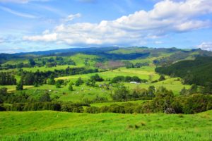
Kotare Village is Based in the North Island – Northern Hawkes Bay, our landscape is divided into main 3 area, the Home Block – is 25 Ha of free draining flat land, the Hill Block is 52 Ha of north east facing slope, gentle and steep in different areas, the River Block is 15 Ha of a typical New Zealand ‘rolling hills’ this is north facing gentle slope / flats, and the whole of the village’s land is sitting within one large catchment of both the Mangaone stream and the Mangapoike river, just before both of those drain into the Wairoa river.
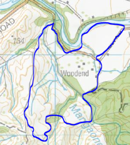
Looking at the map above you can identify the Mangaone, it runs to the north between the hill block (at the south west) and the home block flats, the Mangaone runs year round and has a very gentle drop of about 1m to 100m of length and most of the water on both the home block and hill block run into it (if not caught before in dam, roof or carbon in the soil), the Mangaone spills into the Mangapoike.
The Mangapoike is to the north of the village and water on river block spills into it, it is much larger than the Mangaone though has a similar ratio of drop.
There is a spring on the hill block as well, it runs approx. 8 months of the year and is our drinking water during that time (in the future we will have a dam to collect this beautiful clean water so that we can extend the use of it for the whole of the year) the spring is high enough (50m above the flats) to provide us with clean water in high pressure directly into our reticulation system – no power needed, which feeds into each of the housing sections.
When needed we have been using the Mangaone stream as a water source as well, and in the near future we will have large irrigation dams on the hill block – providing us with high pressure water for all the gardens in the village, until then we are using the existing one dam and pumps to provide this necessity.
Next time on ‘Soils’
Shaked
No comments yet.